
InfoSAWIT, MAMUJU – A total of 31 oil palm smallholders from Pasangkayu Regency, West Sulawesi, participated in the First Batch of Oil Palm Plantation Mapping Techniques Training held on October 23–26, 2026. The programme equipped participants with geospatial skills, ranging from collecting field coordinates to producing digital maps using Geographic Information System (GIS) software.
Organised through a collaboration between the Plantation Fund Management Agency (BPDP), the Directorate General of Plantations, and IPB Training, the programme aimed to strengthen smallholders’ technical capacity to document plantation locations and land boundaries in a more systematic manner.
Mapping skills are considered increasingly important for supporting plantation data collection based on spatial information. Maps developed from accurately measured data can help smallholders identify the locations and boundaries of their plantations. However, the usefulness of such information depends heavily on the accuracy of data collection and proper verification before the data is used.
According to an official statement received by InfoSAWIT on Tuesday (October 27, 2026), the training was attended by Muh. Faizal Thamrin, Head of the West Sulawesi Provincial Plantation Office; Dr. H. Abidin, Head of the Pasangkayu Regency Plantation and Livestock Office; Dr. M. Apuk Ismane of the Ministry of Agriculture’s Agricultural Extension and Human Resources Development Agency; Mula Putra of the Directorate General of Plantations; and Prof. Hariyadi, M.S., a member of the IPB Training instructional team.
Participants Learn the Process from Coordinates to Digital Maps
The training began with an introduction to mapping policies and regulations, geospatial concepts, and the characteristics of spatial data. Participants also learned about the differences between vector and raster data, mapping data sources, and the use of supporting equipment such as GPS devices, smartphones, drones, and GIS software.
This knowledge provided the foundation for subsequent field surveys. Participants learned how to identify mapping targets, prepare surveys, collect coordinates, and trace land boundaries. These steps are essential to ensure that the collected data meets mapping requirements and can be processed accurately.
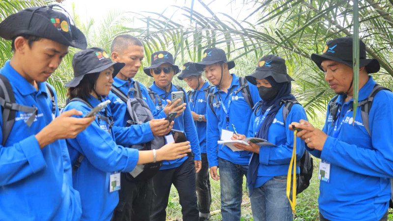
Field practice took place at an oil palm plantation in Polo Lereng Village, Pangale District, Central Mamuju Regency. Participants practised tracking land boundaries, using geotagging to mark plant locations, and operating drones to collect aerial spatial data.
Data collection was a crucial part of the training because the accuracy of coordinates and land boundaries directly affects the resulting maps. Incomplete or inconsistent data must be checked to prevent errors during subsequent processing.
Following the fieldwork, participants learned to process the collected data using GIS software. The lessons covered georeferencing to align data with geographic coordinates, creating vector objects, managing attribute data, and calculating the area and length of mapped objects based on available information.
Participants also learned how to prepare map layouts by adjusting symbols, colours, and other visual elements. These components help ensure that maps are clear and easy to interpret. The processed data was then compiled into final maps and exported for use.
Digital Mapping to Improve Plantation Data Management
The training was designed to introduce participants to the entire mapping process, rather than simply teaching them how to operate mapping applications. Participants worked through each stage, from field data collection and coordinate processing to presenting information in digital map format.
At the end of the programme, participants took part in an integration session and a post-test to assess their understanding of the material.
The skills acquired are expected to help smallholders maintain more structured records of plantation locations and land boundaries. Properly managed spatial information can serve as a source of data to support plantation land documentation.
Nevertheless, the use of digital maps still requires accurate measurements, appropriate processing methods, and verification of the underlying data. Maps must accurately reflect actual field conditions to serve as reliable supporting information for plantation management.
Through the Oil Palm Plantation Human Resources Development Programme, the training represents an effort to strengthen smallholders’ technical capabilities through a combination of theoretical learning and practical exercises. For the 31 participants from Pasangkayu, the ability to collect and process geospatial data is expected to provide a foundation for applying digital mapping to the documentation of their own plantations.
Greater proficiency in mapping technology is expected to support more systematic, orderly, and data-driven plantation management, with plantation locations and boundaries documented more accurately. (T2)